

Description
Product Description:
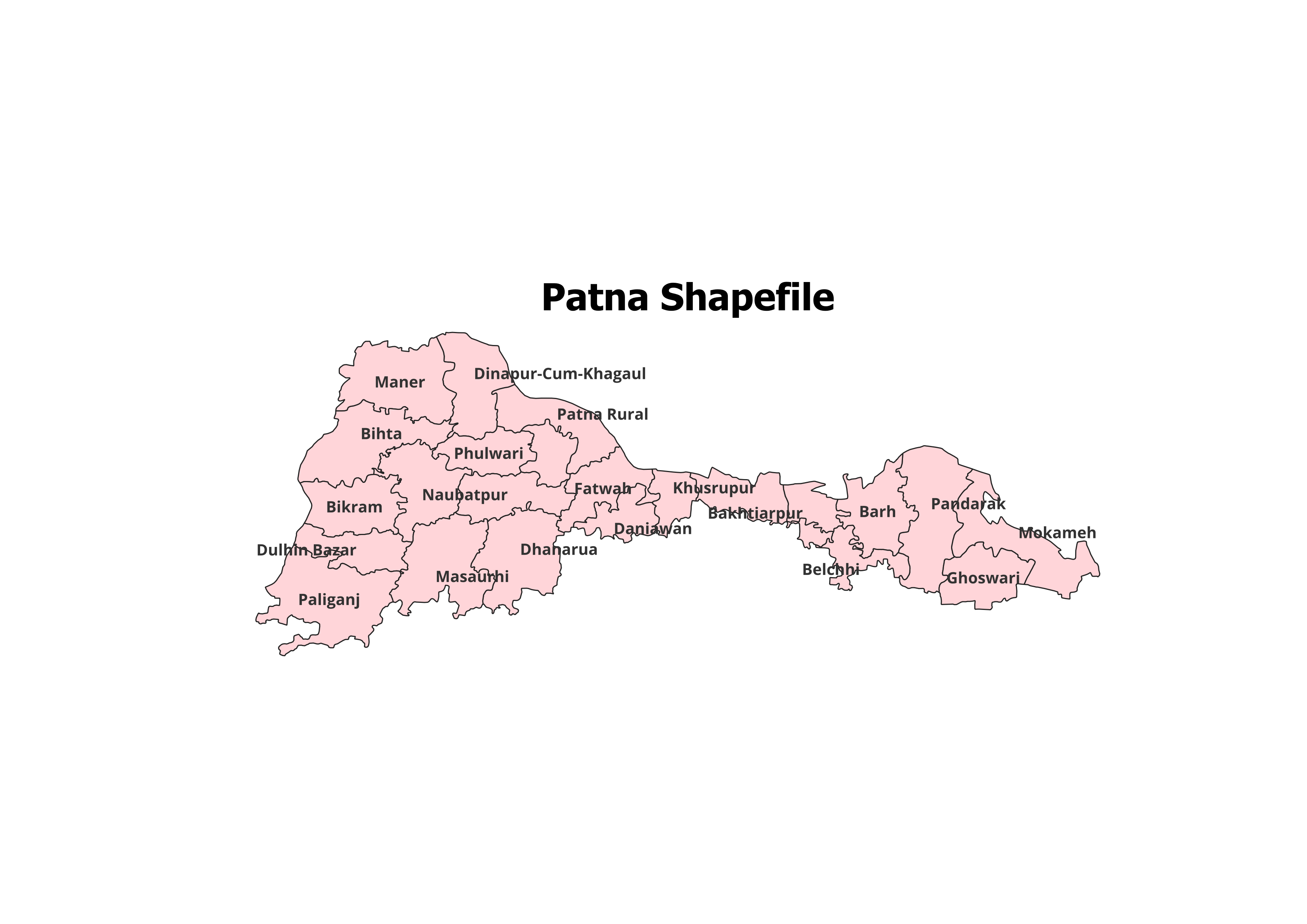
Enhance your geographic analysis with our Patna District Shapefile, featuring precise administrative boundaries of Patna District and its Blocks. Perfect for GIS enthusiasts, researchers, and students, this data enables comprehensive spatial studies with ease.
Key Features:
- Complete Administrative Coverage: Includes all blocks within Patna District, ensuring detailed insights.
- Accurate Data: Authentically sourced and verified for research and academic use.
- Ready-to-Use Format: Compatible with popular GIS software like QGIS and ArcGIS.
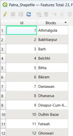
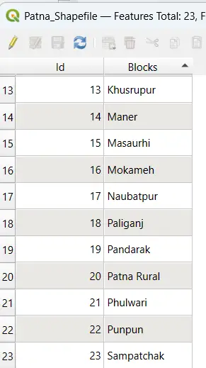
- High Detail: Includes block names and Id for seamless integration into your projects.
- Format Provided: Shapefile (.shp) with support files (.dbf, .shx, .prj).
Applications:
- Research Projects: Study population distribution, land use, and geographic patterns.
- Academic Studies: Ideal for environmental research, urban planning coursework, and more.
- Non-Commercial Analysis: Create maps and perform analysis for personal or educational purposes.
Blocks Included in Patna District:
| Athmalgola |
| Bakhtiarpur |
| Barh |
| Belchhi |
| Bihta |
| Bikram |
| Daniawan |
| Dhanarua |
| Dinapur-Cum-Khagaul |
| Dulhin Bazar |
| Fatwah |
| Ghoswari |
| Khusrupur |
| Maner |
| Masaurhi |
| Mokameh |
| Naubatpur |
| Paliganj |
| Pandarak |
| Patna Rural |
| Phulwari |
| Punpun |
| Sampatchak |
Technical Details:
- File Format: ESRI Shapefile (.shp)
- Coordinate System: WGS 84 (EPSG: 4326)
- Resolution: High-quality vector data
- Attributes: Includes block names, codes, and relevant metadata
Important Notes:
- Commercial Use: Not Allowed. This shapefile is strictly for academic, personal, or research purposes.
- Redistribution or Resale: Prohibited.
What You’ll Receive:
- Shapefile of Patna District
- Metadata with detailed attributes
- Step-by-step instructions for use
- Complimentary technical support
Compatibility:
Compatible with all major GIS software such as:
- QGIS
- ArcGIS
- Global Mapper
- MapInfo
- AutoCAD Map 3D
Licensing:
- Personal and Academic Use Only
- Redistribution, resale, or commercial usage is strictly prohibited.
Download Now and Take Your GIS Projects to the Next Level!
Manish (verified owner) –
I’m impressed by the simplicity and accuracy of the data here. Fantastic resource for GIS professionals.
Siddharth (verified owner) –
As a GIS analyst, I rely on accurate data. This website has never let me down.
Shubham (verified owner) –
The variety and accuracy of the shapefiles here are unmatched. Great job.
Deepak (verified owner) –
Found rare datasets here that I couldn’t locate anywhere else. Great platform for GIS data.
Deepika (verified owner) –
Perfect for GIS professionals and beginners alike. Easy navigation and excellent data quality.
Kiran (verified owner) –
The hydrology shapefiles I downloaded were precise and easy to integrate. Great resource.
Akash (verified owner) –
Excellent customer service and top-notch datasets. Highly recommend this website.