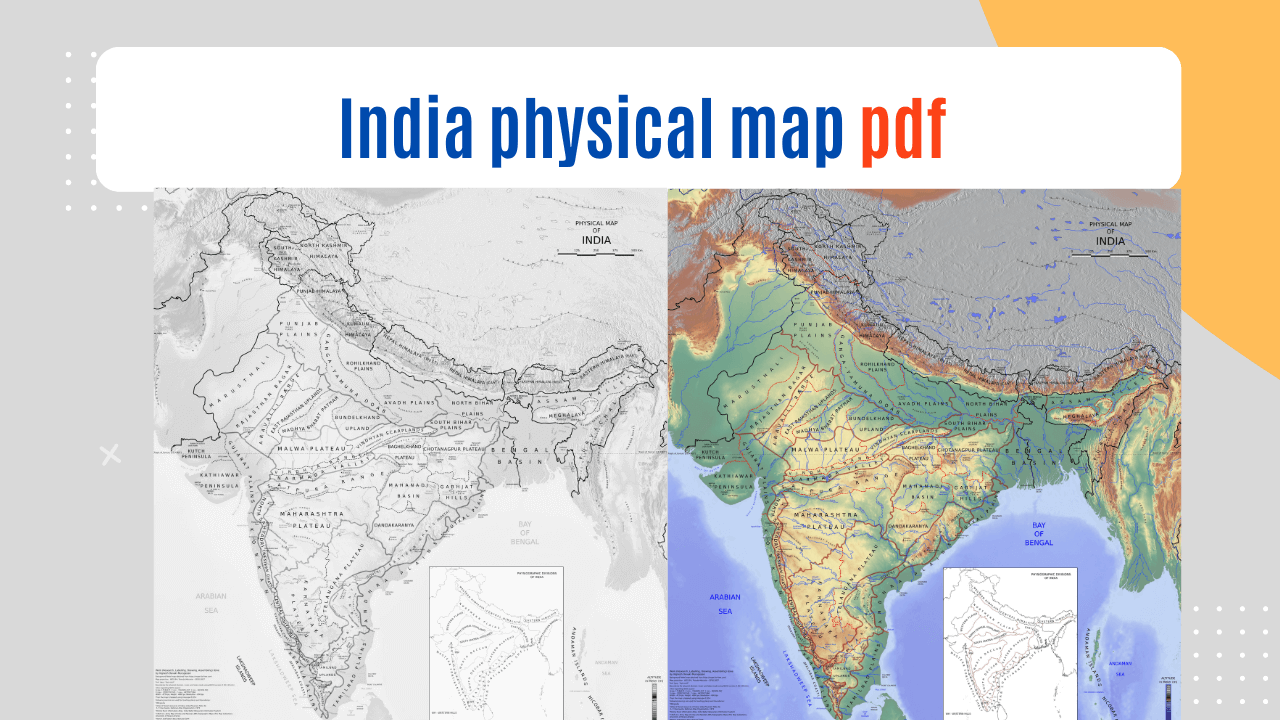
Download the India physical map pdf from the link available in this article. India physical map pdf is free to download using the direct link given here.
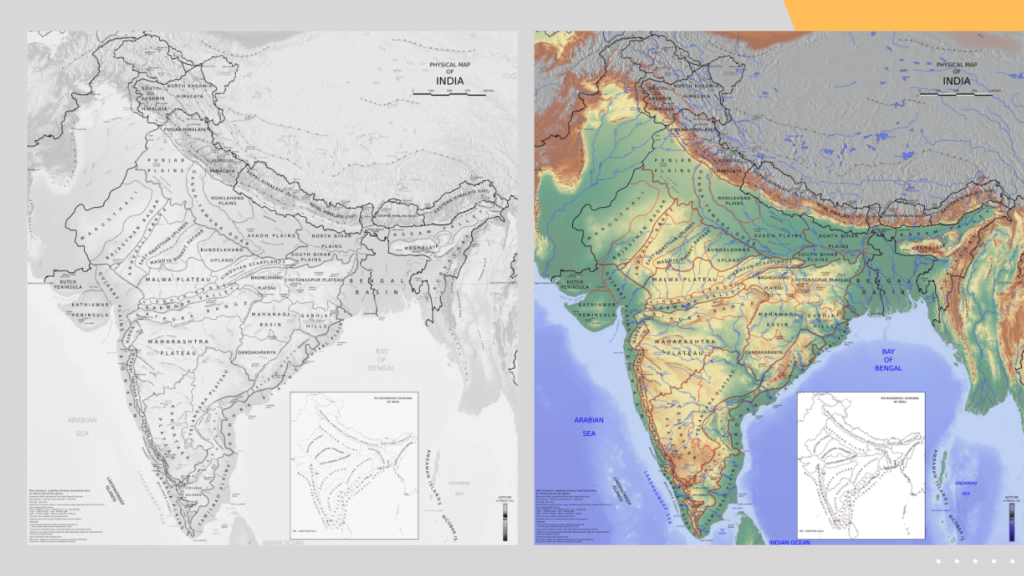
India Physical Map pdf download
(Source: surveyofindia.gov.in)
The India physical map pdf shows that India, the “Land of Diversity,” is culturally, linguistically, and physically diverse. From the Himalayas in the north to the Deccan Plateau in the south and the pristine coastal expanses of the Indian Peninsula, the country’s physical topography is a patchwork of natural wonders. This detailed book will explore India’s physical geography, its regions, geological features, and unique landscapes.
Lets discuss Physiographic physiographic divisions of India which are showing on India physical map pdf.
1. Himalayan Region
The “Abode of Snow,” the Himalayas, is India’s finest glory. This beautiful range borders Nepal, Bhutan, and Tibet in northern India. The Himalayas have three regions:
1.1 The Great Himalayas
The tallest and most northern mountain range in the Himalayan chain is known as the Great Himalayas, or Himadri. It is home to some of the tallest mountains in the world, such as Makalu, Kanchenjunga, and Mount Everest. These enormous mountains, which are always shrouded in snow and ice, are the source of many rivers that feed the lowlands below.
1.2 The Lesser Himalayas
The Lesser Himalayas, often referred to as the Himachal or Middle Himalayas, are located south of the Great Himalayas. Lower elevations distinguish this area, which is well-known for its verdant woods, scenic hill towns like Shimla and Manali, and an abundance of wildlife. Between the Great Himalayas’ soaring peaks and its foothills, the Little Himalayas serve as a barrier.
1.3 The Outer Himalayas
The Shiwalik Range, commonly known as the Outer Himalayas, is the Himalayan chain’s southernmost range. This area is well-known for having foothills covered in thick forests and relatively low heights. It serves as a transitional area between India’s northern plains and Himalayas.
2. Northern Plains
We enter the huge Northern Plains, also known as the Indo-Gangetic Plain, as we go south from the Himalayas. Due to the rich alluvial soil that the rivers that come down from the Himalayas have deposited, this area is one of the most fertile and agriculturally productive locations in the entire globe.
2.1 The Indo-Gangetic Plain
Several mighty rivers, including the Ganges, Yamuna, Brahmaputra, and their tributaries, pass across the Indo-Gangetic Plain. These rivers have enormous cultural and religious significance in addition to providing water for agriculture. Cities like Varanasi and Patna, which are some of the oldest in the world, are scattered throughout the plain.
2.2 The Thar Desert
The Thar Desert, which contrasts sharply with the Gangetic Plain’s verdant plain, is located to the west of the Northern Plains. Huge sand dunes, sweltering heat, and a distinct desert environment define this dry area. The Thar Desert extends into Pakistan across the border, where it is inhabited by resilient people who have adapted to the harsh desert environment.
3. Peninsular Plateau
As we move further south, we encounter the Peninsular Plateau, a vast tableland that covers much of southern India. This plateau is divided into two main sections:
3.1 The Deccan Plateau
The centre and southern regions of the Indian Peninsula are covered by the Deccan Plateau. Rolling hills, plateaus, and lava plateaus that were created by ancient volcanic activity are its defining features. Many significant rivers, including the Godavari, Krishna, and Tungabhadra, may be found on the Deccan Plateau and are essential to the region’s agriculture.
3.2 Western Ghats
The Western Ghats are a rough mountain range that lies to the west of the Deccan Plateau and parallels India’s western coast. The Western Ghats are well-known for their lush rainforests, plethora of species, and countless waterfalls. They are also a hotspot for biodiversity. Many UNESCO World Heritage Sites are located in this area, which is a veritable treasure trove of natural beauty.
3.3 Eastern Ghats
The Eastern Ghats, a collection of irregular hills and plateaus that run along India’s eastern coast, are located on the eastern side of the Deccan Plateau. While perhaps not as well-known as their western counterparts, the Eastern Ghats are nonetheless significant from an ecological and cultural standpoint.
4. Western Coastal Plains
The Western Coastal Plains run parallel to the Arabian Sea and lie between the Western Ghats and the Arabian Sea. They are divided into two distinct regions:
4.1 Konkan Coast
The Konkan Coast is the northern Western Coastal Plains. This region has palm-fringed beaches, rich vegetation, and many estuaries. Mumbai, Goa, and Mangalore are famous tourist destinations on the Konkan Coast.
4.2 Malabar Coast
The Malabar Coast is the southern Western Coastal Plains. Its spice trade, backwaters, and beaches are famed. Kerala, “God’s Own Land,” is on the Malabar Coast and known for its natural beauty and culture.
5. Eastern Coastal Plains
On the eastern side of India, we find the Eastern Coastal Plains, which lie between the Eastern Ghats and the Bay of Bengal. This region can be further divided into two parts:
5.1 Coromandel Coast
The Coromandel Coast is the northern Eastern Coastal Plains. Rivers like the Mahanadi, Godavari, and Krishna generate vast deltas. Fertile soil promotes agriculture and rice farming in the region.
5.2 Northern Circars
The southern part of the Eastern Coastal Plains is known as the Northern Circars. This region is relatively drier compared to the Coromandel Coast and has a mix of agricultural land and coastal features.
6. Islands of India
India is not just a vast landmass; it also includes several islands that are scattered across the Arabian Sea and the Bay of Bengal.
6.1 Andaman and Nicobar Islands
The Andaman and Nicobar Islands are 572 islands and islets in the Gulf of Bengal. Known for its beautiful beaches, lush jungles, and unique indigenous cultures. Coral reefs and underwater wildlife make the Andaman Islands famous.
6.2 Lakshadweep Islands
The 36 coral atolls and reef islands of the Lakshadweep Islands lie in the Arabian Sea. Clear blue waters, coral reefs, and abundant marine life characterize these islands. Water sports and ecotourism are prevalent in Lakshadweep.
7. Conclusion
India’s physical map shows its immense geographical diversity. India’s geography is breathtaking, from the Himalayas to the Indo-Gangetic plains, the Thar Desert to the Western and Eastern Coastal Plains.
Each region of India has its own history, traditions, and way of life, thus exploring its physical map is a voyage through time and culture as well as landscapes. India’s physical map provides something for everyone, whether you’re an adventurer seeking the thrill of the Himalayas, a beach lover seeking clean coasts, or a nature lover seeking rich biodiversity. Pack your luggage and explore India’s natural splendour, where nature never ceases to surprise.
DISCLAIMER:
The content, including the India physical map pdf, contained within this PDF is the exclusive property of the respective copyright owner or publisher. We explicitly disclaim any ownership or copyright claims regarding the India physical map pdf. Also does not warrant or guarantee the accuracy or completeness of the contents presented within the PDF.